
Foggy Bottom sidewalks are too narrow to enable effective social distancing, according to a new website launched late last month.
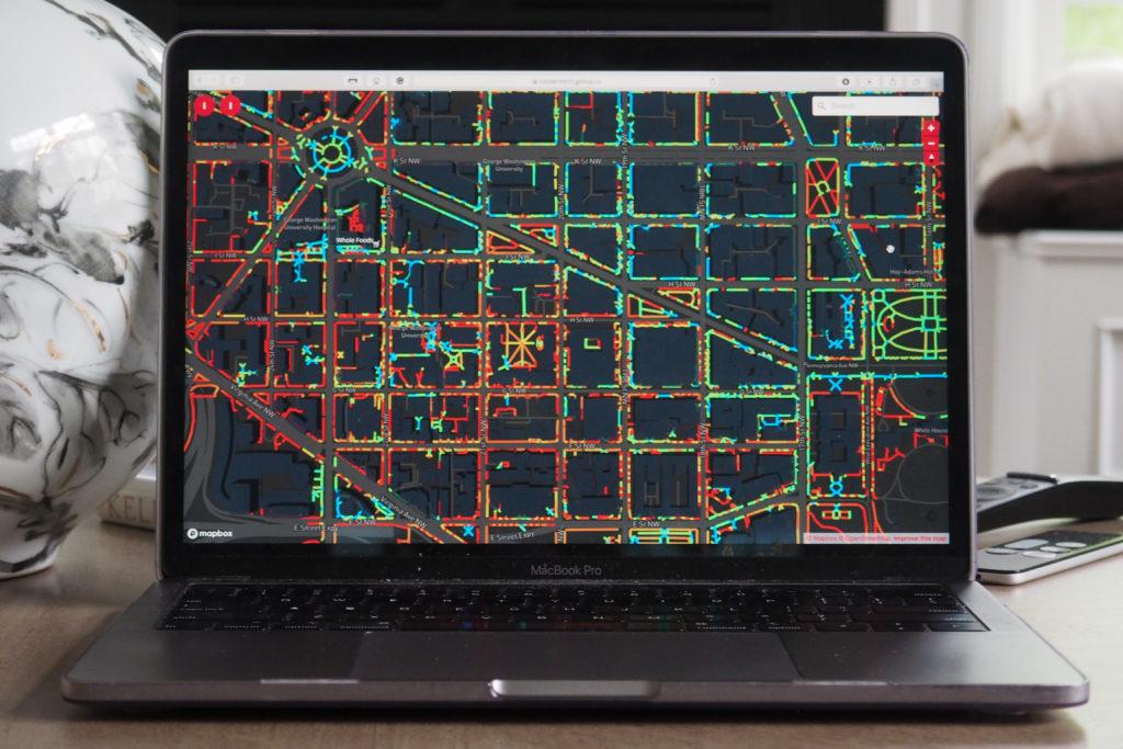
The website, named “Sidewalk Widths DC,” features an interactive map aimed to highlight a sprawling network of D.C. walkways too narrow to create the six feet of separation required for social distancing. Alumnus Matthew Holden, a geospatial data scientist for Wells+Associates – a transportation planning company – said he launched the website April 27 to increase the public’s awareness of social distancing limitations on sidewalks and paths throughout the District.
“Narrow sidewalks on busy streets matter when people are trying to social distance because of public health and coronavirus issues,” he said.
The website marks walkways up to 14 feet wide as either “too narrow” or “difficult” for pedestrians to social distance, whereas all other paths can allow for social distancing to occur. Holden said he used social distancing guidelines that require six feet of separation to decide whether or not a walkway was too narrow.
The blocks that cover GW’s campus are part of the issue, according to the website’s map. Walkways narrower than 14 feet appear on each block of campus and nearly surround blocks housing the Science and Engineering Hall, Shenkman Hall, University Yard and Potomac House, the map shows.
Holden’s site features a map of D.C. with color-coated lines running down the center of every sidewalk or path throughout the entire District. The lines switch color among sidewalks in increasing order of width from less than 10 feet in red to orange to tan to yellow to green to blue, which includes all walkways 20 feet and wider – considered “great” for social distancing.
Red dominates nearly the entire map, lining District streets narrower than six feet from Southeast to Northwest. The National Mall in addition to circles and parks scattered throughout the region like Washington Circle and Lafayette Square serve as the few locations with ample spacing for social distancing to occur, according to the map.
Holden said he was motivated to publish the website after seeing other cities like Oakland, Charlotte and Seattle implement new policies to expand sidewalks or block traffic to allow pedestrians more space to socially distance outdoors. He said he noticed how D.C.’s sidewalk extension measures near storefronts failed to match other legislative efforts in these other cities throughout the country.
Mayor Muriel Bowser shut down the National Mall and Tidal Basin in March after tourists crowded the area to catch a glimpse of the season’s cherry blossom bloom, stirring widespread concern for the District’s social distancing enforcement.
“The city hadn’t really announced a plan to do this like a lot of other cities had,” Holden said. “They announced they were going to slowly extend some sidewalks in front of some grocery stores, but nothing city-wide. I was thinking about how to make a map or do something like this to bring attention to the issue.”
Office of the Mayor spokeswoman LaToya Foster did not return a request for comment.
Bowser announced a plan last month that expanded sidewalks in five locations, including the placement of parking barriers in front of the Trader Joe’s sidewalk near Washington Circle. Holden said sidewalk improvements like those at Trader Joe’s, which installed barriers in an adjacent parking lane, have fallen short of creating new walkways that would protect pedestrian safety throughout the entire District.
“They put all these concrete barriers up, but it didn’t in effect really give any more space,” he said. “They’re doing some things like that, but they aren’t creating networks where people can actually move from place to place.”
Holden said a similar New York website called “Sidewalk Widths NYC,” which launched earlier last month to outline how sidewalks affect social distancing in New York City, served as another city-wide initiative that inspired him to create his own website. He said he adapted the code used to construct the NYC map and used mapping data from the D.C. government’s website to design the site.
Holden, who lives in Dupont Circle, said his neighborhood’s sidewalks are narrow and lose even more space because of barriers like trash cans and tree beds planted into public walkways. He said pedestrians have to step into the street and in the way of oncoming traffic to avoid getting too close to other neighborhood locals.
“Everyone has that experience of walking in the city,” he said. “But a map like this that has the whole city and you can see the pattern throughout the city, it’s like ‘Oh it’s not just my neighborhood that is experiencing this or where I’m experiencing this. This is an issue for lots of people.’”
Holden said he received positive feedback after he communicated his map’s findings with the Dupont Circle Advisory Neighborhood Commission, a local governing body, which has been sharing the map with other ANC members.
James Harnett, a senior and the Foggy Bottom and West End Advisory Neighborhood Commission’s vice chair, said Foggy Bottom sidewalk space is limited because of the wideness of the streets that run through campus. He said neighborhood leaders need to start considering ways to convert roadways to pedestrian space and limit on-street parking.
“Our sidewalks are simply too narrow to allow for pedestrians to safely physically distance from one another on the scale of thousands of people in a neighborhood that traditionally has wide roads for its vehicles,” he said.
Harnett said ANC members and officials who serve as neighborhood “stakeholders” should consider sidewalk extensions, road closures and cycle lane protections to ensure pedestrians can practice social distancing in public spaces like sidewalks on campus.
“We need to try out things that we’ve never done before and upend the status quo that we have for too long relied on as part of our transportation policy to keep people safe,” he said.